Family-Friendly to Rugged Riding
Robbins Hill Scenic Area
Location: On US-201 just north of the intersection with ME-43.
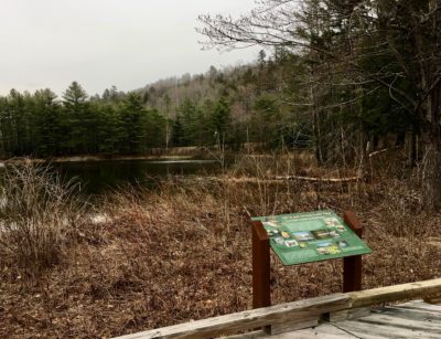
Bike or walk the Wes Baker Trails that wind through open meadows and into the forest. Picnic under shelters or choose from the tables and benches scattered through the upper field. An information panel helps to identify the mountains in the western range. Restroom facilities are available.
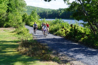 The Kennebec Valley Trail
Location: Bingham to Embden
Length: 7.3-mile long multi-use trail
The trail follows the Kennebec River to Solon where it crosses the river and flanks the west side of US-201A. Once a railroad bed, it’s a very family-friendly graveled bike. It’s a popular trail for ATVs in the summer and snowmobiles in the winter. Dogs must be leashed.
The Forks Area Scenic Trails
The trail system in The Forks area is enjoyed year-round. Walk, bike, ski, or snowmobile this system. The Ball Field in The Forks serves as a hub for the trail system. A walking/snowmobile bridge connects the Ball Field to a rest area with picnic tables on the opposite side of the river. Portapotties are available at the Ball Field. This is also a popular spot to launch kayaks and canoes.
The River Trail, along the Kennebec River just north of Caratunk, is ideal for running and biking in the summer and snowmobiling in the winter. This 3.6-mile trail ends before crossing US-201 to Flood Road, and is a family-friendly trail and ADA-compliant for about a half mile. To find it, it’s about one mile north of the Appalachian Trail Crossing on US-201 in Caratunk. Turn into the parking lot at The Forks town line. There are two picnic tables here, but no restroom facilities. The trail begins to the left on the bank of the river. On the trail, stay to the right as you enter the woods and go over the Holly Brook Bridge. In the summer one can see an abundance of foxglove flowering (poisonous to dogs).
 The trail then cuts through a couple of rafting campgrounds along the way before meandering around the Pooler Ponds where there is a picnic table and opportunities to view wildlife. After crossing through another camping area, the trail follows along the top of an esker (not ADA-compliant) across from Northern Outdoors Center. There’s also a parking area (not marked and no restroom) at the Pooler Ponds and another on the left just north of Martin Pond on US-201.
The Ridge Trail is a 2.7-mile trail, that connects The River Trail to the Ball Field in The Forks. At the end of The River Trail, one must cross Rt. 201 to access Flood Road. Though walkable as a moderately challenging hike, this trail is rough for biking unless you are an experienced mountain biker. At the top of Flood Road, one has a lovely view of the river. There’s a fairly steep incline near Flood Road. The easiest access is in The Forks is behind the Marshall Hotel. Parking at the Ball Field is recommended.

The Dead River/Salmon Stream Trail, along the Dead River, is a 1.7-mile family-friendly trail and ADA-compliant for most of its length starting at the cemetery parking lot. There are several nice picnic tables available, but no restroom facilities. Salmon Stream Trail connects to the Huts & Trails system. To access the trail, drive just beyond the Hawk’s Nest Lodge on Rt. 201 in West Forks, take a left onto the Dead River Rd. You’ll see a sign for the Maine DOT sand/salt lot. Drive a short distance until you come to the trailhead parking lot near a family cemetery. If so inclined, one can also park at the Ball Field (restroom facilities available) near the bridge that spans the Kennebec River, and either walk or ride a bike to a trail access that’s directly across the street from the Hawk’s Nest Lodge. There is no sidewalk on Rt. 201.
Jackman Area
Rancourt Pond Loop Trail
Location: Jackman
Length: 11-mile loop
Difficulty: moderate hard-packed dirt road with rough eroded sections and stream crossings. There are several challenging technical sections. Trail conditions vary depending on season and weather.
Start out early in the morning and peddle quietly for optimum wildlife viewing. Watch for moose in the early mornings and evenings! Head north on US-201 from Sky Lodge for 2 miles and turn left onto Holeb Road, a road with powerlines just past the Borders Riders Snowmobile Club. Head down the road and turn left onto a small jeep trail. If you come to a bridge, you’ve gone too far. The jeep trail goes to Sandy Stream where you’re likely to get wet when you cross!
A map of this trail and other mountain bike trails in the Jackman area can be found at Bikekinetix.