TAKE A HIKE
Hiking the trails through woods, along rivers, and up mountains is a very popular activity on the Old Canada Road. Trails in the area are free to the public and offer visitors a variety of trail types with views of unspoiled beauty in all directions.
What to Pack
Camera, binoculars, a field guide to trees & plants, a trail map (cell service can be spotty!), compass, windbreaker/poncho, bandana/hat, sunscreen/bug dope, sunglasses, snacks/water, litterbag and a hardy sense of adventure. Wear sturdy shoes. Some hikers like to use hiking poles.
Climb a mountain.
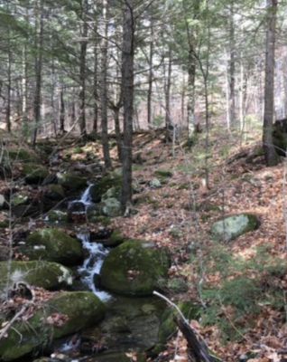
Dip your feet in a cold mountain stream.
Listen to the woodland birds.
Enjoy the view from an open ledge.
Our Favorites
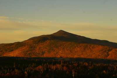 Coburn Mountain
Distance: 1.4 miles
Difficulty: Challenging
The views are outstanding from this 3,718-foot mountain’s small observation deck.
Follow US-201 to Enchanted Mountain Road just beyond Parlin Pond. Travel 2.1 miles down Enchanted Mountain Road.
The Enchanted Mountain Road is passable but is a rough road. Say right when the road splits early on. You’ll come to the old Enchanted Mountain ski area base, where you can park. The trailhead is 0.2 miles away from the parking area.
The trail is really steep. You climb a good way on this rocky route, for approximately 1 mile, until you reach a small radio tower. Continue ascending on the snowmobile path for 150 feet. You’ll see the footpath on your right, marked with a cairn. It heads into mossy spruce woods. In about .25 miles you’ll reach the open top, where there’s more radio equipment and the viewing platform. To return, you can take the footpath back down, or follow the longer (8/10 of a mile) and gradual snowmobile path, which offers some additional views but can be quite wet in some areas.
Moxie Falls
Distance: .6 miles
Difficulty: Easy hike on well-maintained trails/boardwalk/stairs
See more details about this spot on our Waterfalls page.
Moxie Mountain
Distance 1.6 miles to summit from Heald Pond Road
Difficulty: Challenging
While this mountain is wonderful, the drive to the trailhead off Heald Pond Road is long, rough, and rocky. Best to have a high-clearance vehicle.
The southern trail departs from Heald Pond Road. It takes about 23 minutes from Bingham. In Bingham, turn onto ME-16 E. In 0.5 mi turn onto Stream Rd. Follow Stream Rd then turn right onto Dead Water Rd. Drive 0.4 mi and bear left onto Heald Pond Rd. Drive 0.9 mi to the trailhead.
The trail is very well marked with cairns, signs, and plastic blue tags. It starts off on an overgrown logging road before taking a sharp right (marked with a cairn and an arrow) into a low spruce forest interspersed with sections of loose rock. This trail goes steeply uphill. At about 1.2 miles, you’ll see a side spur leading to an outlook. Shortly after that, you’ll reach the intersection with the West Trail heading down to Deer Bog. Stay right at this point to reach the summit in 0.4 miles.
It has fairly wide expanses of arid, rocky areas that look a bit like they could be the surface of the moon. Also, at the top, like many other mountains, there is a radio tower powered by solar panels and a helipad.
 Moxie Bald Mountain
Part of the Appalachian Trail- Kennebec & Moose River Region
Distance: 9.6 miles
Difficulty: Strenuous
This is a beautiful trail with ledges, moss, and spruce-covered hillsides. Catch views of Bigelow, Katahdin, Sugarloaf, and Abraham mountains.
Take US-201 N from exit 133 off the Maine Turnpike to The Forks, and turn right onto Lake Moxie Road, just before the Kennebec Bridge. At Lake Moxie Station/dam, turn right onto Troutdale Road and proceed about 8 miles to an AT marker where there is parking on the right. The trail goes off to the left side of the road and crosses a brook. It is one mile to Joe’s Hole Lean-to.
Owl’s Head Trail
Jackman, ME Upper Kennebec Valley Region
Distance: 1.5 miles round trip from the trailhead
Difficulty: Easy to Moderate
Attean Scenic Overlook is on US-201 just before you get to Jackman and has spectacular views of the surrounding mountains and lakes. This overlook is a rest area with picnic tables and portable facilities and is the beginning of the Owl’s Head Trail. The trail is clearly marked and is family-friendly.
Magic Falls Trail on the Kennebec River
Moxie Gore Township-Upper Kennebec Valley
Distance: about 4 miles round trip
Difficulty: Easy to Moderate
Magic Falls is an exciting set of whitewater rapids on the Kennebec River. This is where the photographers go to take pictures of rafting trips and you can watch rafters challenge the falls.
Follow US-201 N to The Forks, then right onto Lake Moxie Road, just before the Kennebec Bridge. Proceed 5 miles to Lake Moxie and turn left onto The Harris Station/ Indian Pond Road. Travel 4.7 miles to where the road crosses Black Brook. Turn left onto Take Out Road. About 1.4 miles in on the right is a small pullout at the trailhead. Park here and hike two miles. Watch for wildlife! A trail to the left goes down the bank into the gorge. It will be steep and more difficult at this point. Be careful!
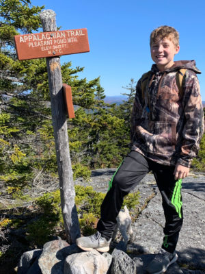 Pleasant Pond Mountain
Caratunk, ME
Distance: 1.2 Miles from AT Lean-to
Difficulty: Moderate
Pleasant Pond Mountain has an open ledge peak, scattered with small trees and a 360-degree view. The trail is steep in places and there are rocks to climb over. Hiking poles are helpful.
Take US-201 N to Caratunk. Turn into Caratunk just past the Sterling Inn. At 0.3 miles, across from the Post Office, take the Pleasant Pond Rd. At approximately 3.7 miles the road forks. Keep left on North Shore Rd. The pavement will end and the road narrows. Drive down over a hill and watch on the left-hand side of the road to find the trailhead. Don’t pass through either of the yellow gates you see. Do not drive down the North Cove Road.
Mosquito Mountain
Distance 1.2 Mies
Difficulty: Easy to moderate
Mosquito Mountain is a ledge-topped gem, with a 360-degree view overlooking Moxie Pond, Moxie Bald Mountain, and Pleasant Pond Mountain. Bigelow Mountain can be seen in the SW and Big Moose Mtn to the NE. Take US-201 N to The Forks and then take a right onto Lake Moxie Road, just before the Kennebec River Bridge. Travel 5 miles to Moxie Pond and take a right onto Troutdale Road. Follow this dirt camp road approximately 2 miles to a pull-out where the road and power lines meet and where you should be able to see Mosquito Mtn and proceed to the trail.

No. 5 Mountain
Distance: 2.6 Miles
Difficulty: Moderate
This mountain is in the Leuthold Forest Preserve. The trail is forested until it emerges close to the ledgy summit, which has an intact fire tower that The Nature Conservancy warns people not to climb.
From US-201 N, turn onto Spencer Road (aka Hardscrabble Road) and continue 16.6 miles to the trailhead, marked with a Nature Conservancy sign. The hardest part of this mountain is driving the 17 miles or so to the trailhead on back roads. If you have the vehicle to do this, you’ll eventually see a small Nature Conservancy trail sign at mile 16.6. Most cars should park here and hikers should walk the .5 miles up the rough jeep track. At the open grassy area, you’ll find a large and informative trail kiosk that has a trail map and information about the many thousands of protected acres in this area.
From this point, the trail ascends for about 0.4 miles up an overgrown logging track. This section of the trail is not marked but is easy to follow. At 0.4 miles, watch for Nature Conservancy signs and the blazed trail to your right. Follow this another 1.6 miles (it is well marked), to the summit.
Fletcher Mountain in Young’s Wildlife Preserve
Difficulty: Easy loop; takes about an hour
Distance: 1.9 mi. and 524 ft elevation
Directions: Cross the bridge in Bingham to ME-16 W. Turn right onto Ridge Rd. Turn left onto Bluff Rd. Slight right onto Fletcher Mtn Rd. Look for the parking lot provided by Somerset Woods.
The loop trail goes up Fletcher Mountain and also to the beaver pond across the road. This short trail, opened in 2019 by Somerset Woods Trustees, travels just over 0.1 miles to the edge of a beaver pond, presenting excellent opportunities for wildlife watching. This trail is great for birding, hiking, and snowshoeing. Dogs are welcome.
Great Carrying Place Portage Trail
Trail Access: Take ME-16 W from Bingham. Turn right onto Ridge Road; turn right onto Carry Pond Rd; Trail is approximately 8 miles from the junction of Pleasant Ridge Road and Carry Pond Road. An alternative is to access the ferry service in Caratunk.
Do’s & Don’ts on the Trails
- Be respectful of the surroundings. Don’t mark up or deface trees.
- Pack in/pack out all trash.
- Be careful where you step.
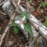
- Don’t squash that rare white-painted trillium beside the trail!
- Take nothing but pictures and leave nothing but tracks.
Additional excellent resources for area Trails are the AllTrails website, Maine Trail Finder, and Maine by Foot. Come and enjoy hiking the trails off the Old Canada Road!